
“Well, there is always the mega-bail.”
[blank stare from Devon]
“We could just walk to Pinedale and pay someone to drive us to the car?”
It was day 8 of our planned 19 day summer traverse of the Wind River range and things were not going according to plan. My down sleeping bag was wet, all of our layers were soaked, and there was 3 inches of snow outside. A stiff frozen breeze pressed us from the west. After 5 days of unseasonable weather we needed to consider some options. Our plan hadn’t survived reality and we needed a new one.
The wilderness though, wasn’t our enemy. It was our teacher and it was trying to tell us something. We picked a goal we weren’t really sure we could complete, in a range with a variety of terrain that we knew would test us. It was never supposed to be easy. While we had already missed out on some of the climbing we were looking forward to, there was plenty more to do. The weather was supposed to break and we had 11 more days in the heart of one of the greatest American mountain ranges. The Winds were asking us what we wanted to do for ourselves instead of the arbitrary line we drew on our computers at home.
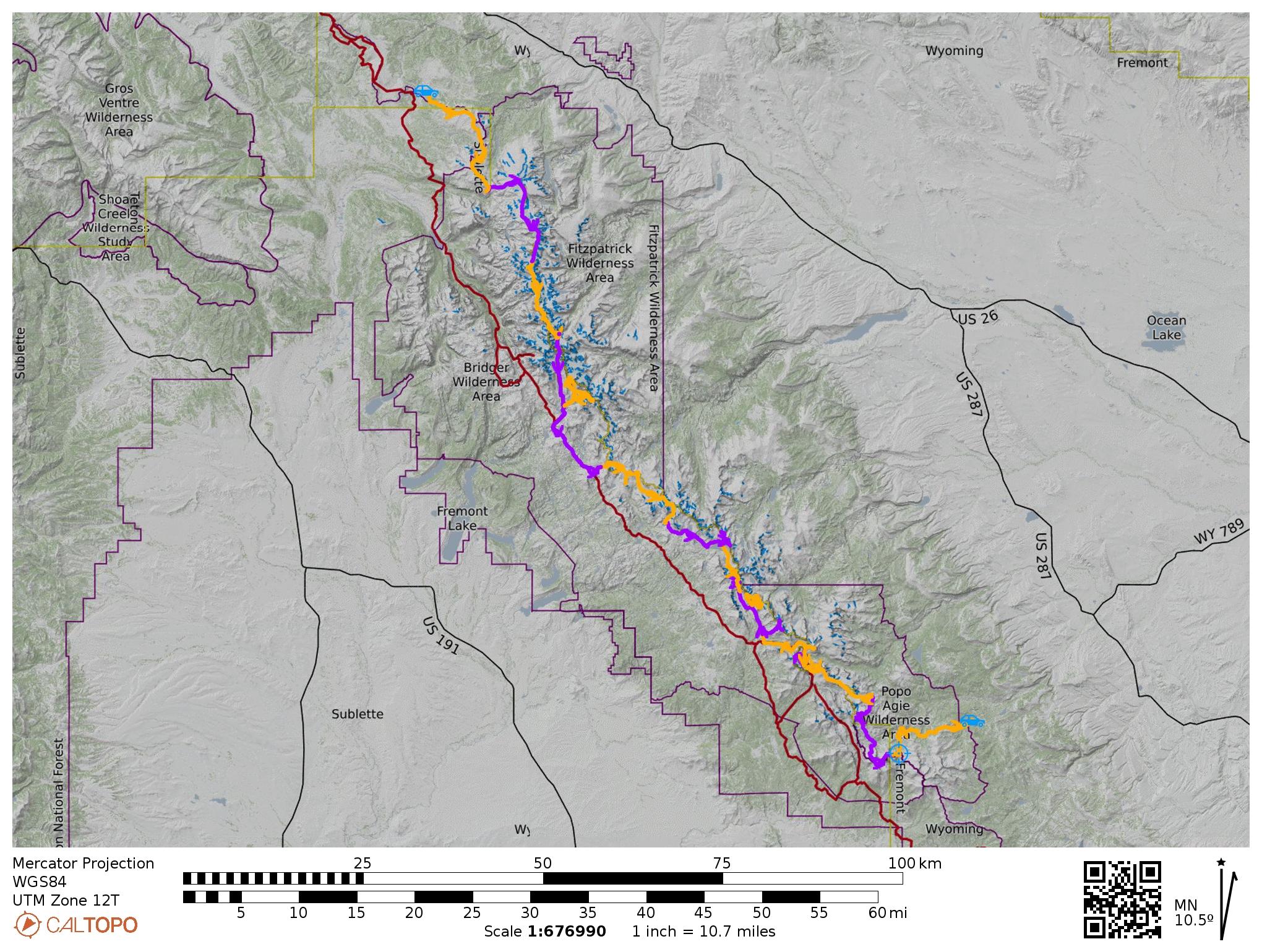
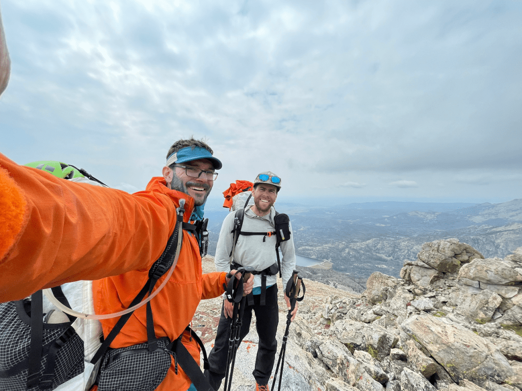
Devon and I have enjoyed so many adventures since becoming friends in 2015. Seeing our lives only getting more complicated, Devon said it first: “we need to do something big together.” A long trip, in a wild place, that would challenge us, but that still seemed in the range of our abilities. Something that our wives wouldn’t miss joining in on and would warrant sacrificing some of our other adventure pursuits. Working late one night in the fall of 2018, I read a trip report called “Ride the Winds” in the Alpinist newswire- two legendary NOLS instructors attempted to summit all 43 named peaks on the Continental Divide between Union Pass and Sweetwater Gap. The variety of terrain, remoteness, clarity of the line, and magnitude were a perfect fit. Their goal became our goal, and we started planning in January of 2021. Despite working similar roles at the same firm, we finagled 3 weeks off in August and I outlined a training plan starting in March.


Horizontal lightning cracked boldly across the black Lander sky- it seemed our trip might start out rather wet. My old friend Sylvia* and her partner Bryan* were spending the summer in Lander and graciously offered to shuttle us out to the trailhead (6hrs round trip!). We camped with them the night of August 14th, grabbed breakfast early Sunday morning, and drove north without being certain that my Prius would actually make it all the way to the ATV road we hoped to walk in on. As we drove north, the crest of the Wind River range loomed over us to the west- it would be a long walk back to the car.
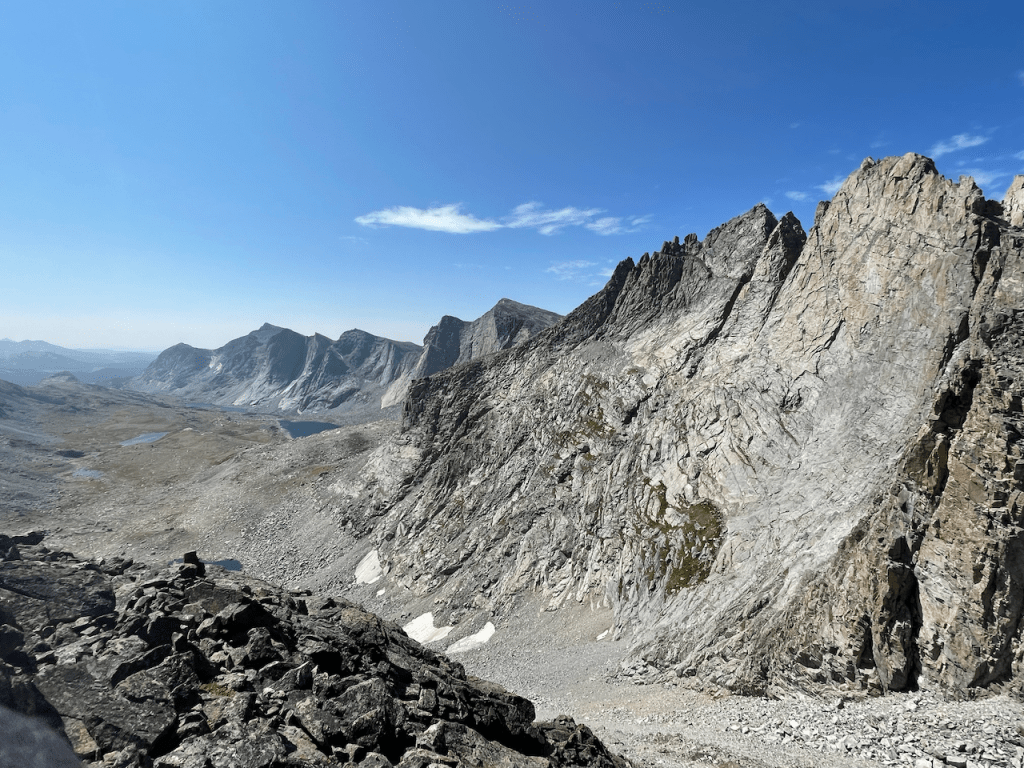
We started with 8 days of food, high clouds over mild smoke, and hearty aspirations. We followed a two-track until the ridge split south, then started off trail towards Union Peak. Above the tree-line, off trail walking felt straightforward and we made good time. Later that day, dark clouds piled up to the west as we climbed the east slopes of Three Waters Mountain. The lactic acid in our legs forced the first instance of a common question- “do we push on?”
“Let’s rest until we’re ready to push, then yes.”
A short rain squall passed quickly and we logged as many extra miles as we dared.

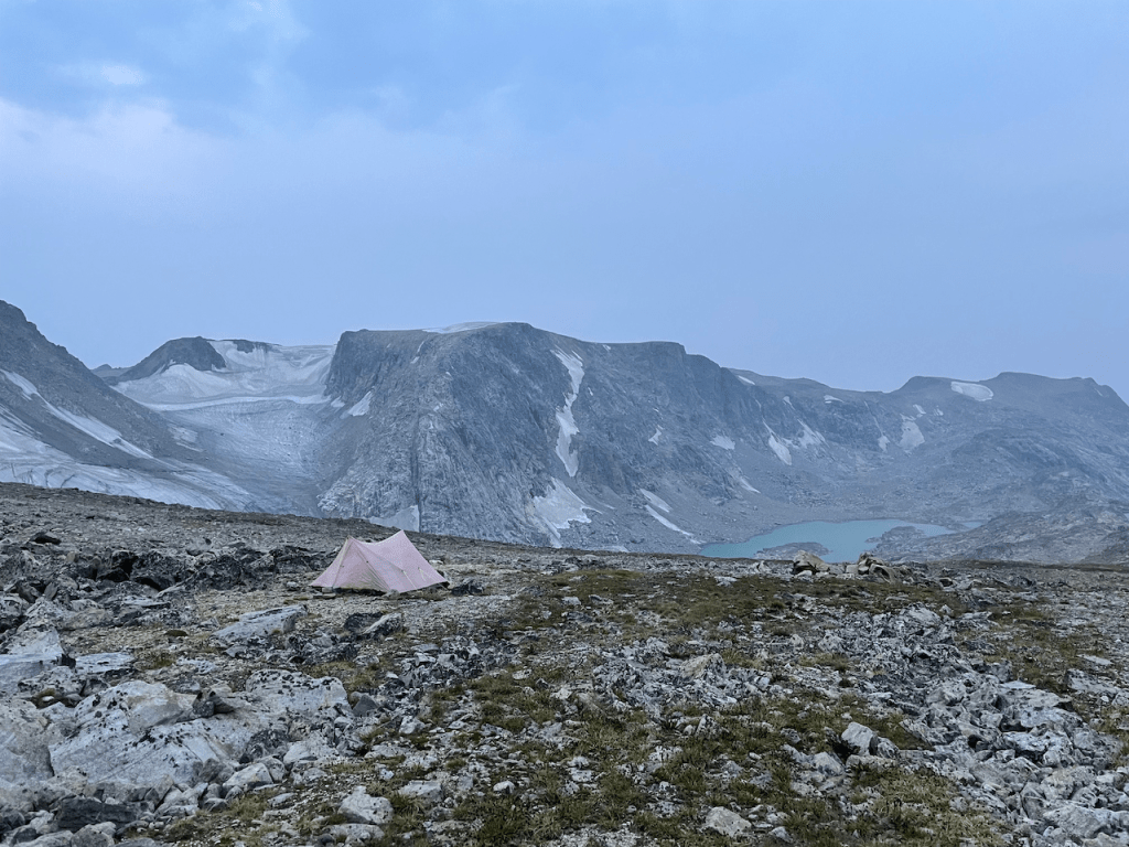
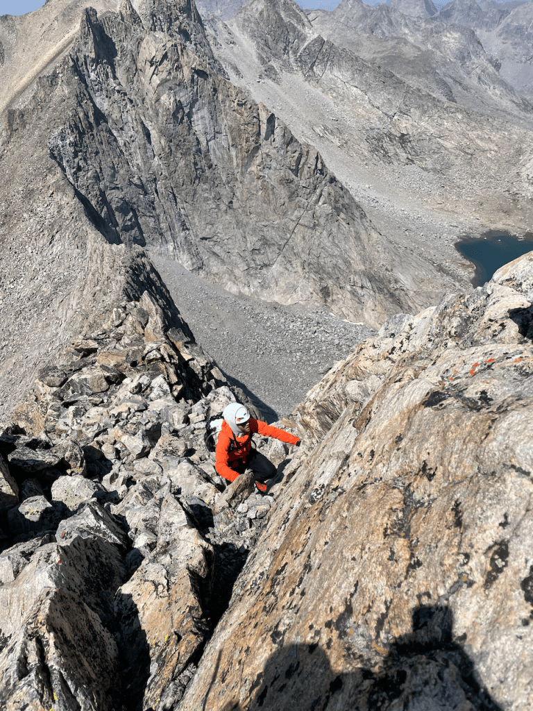
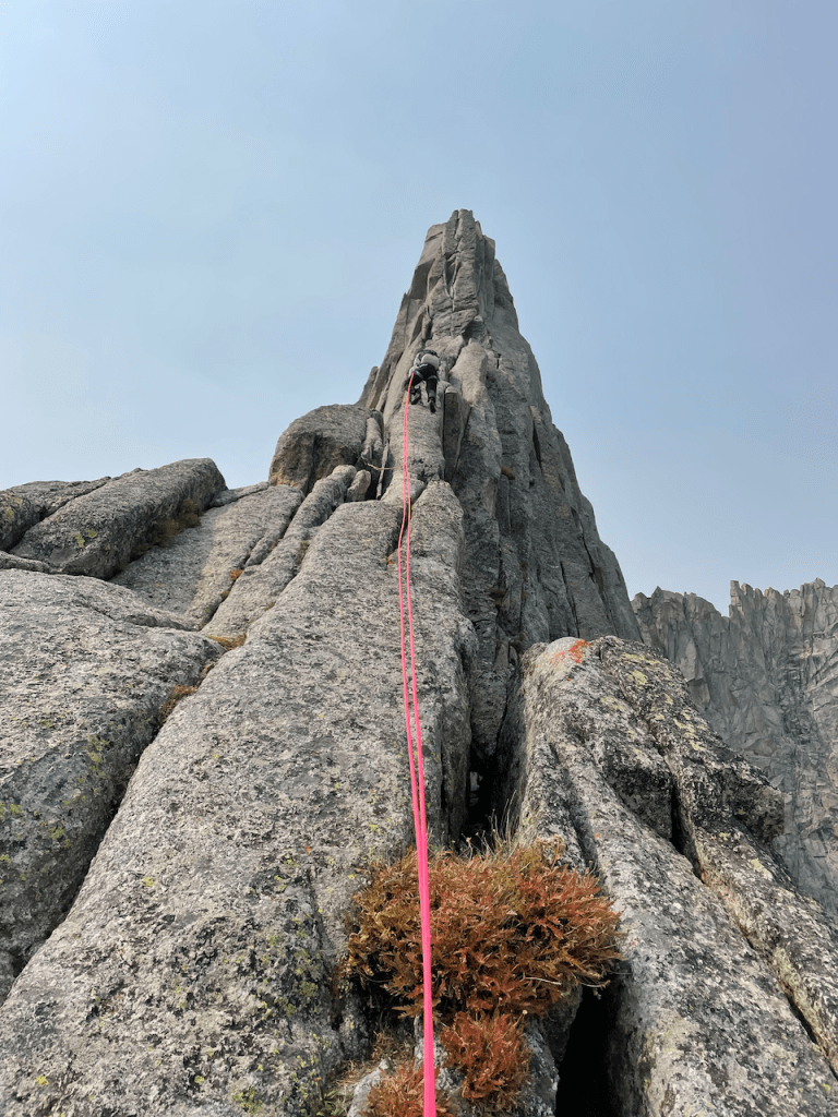
After a strong first day effort, we found great camping and recovered well. Day 2 pushed us above 13,000ft to tag summits on Shale Peak, Gjetetind, Northwest Peak, and Downs Mountain. The altitude and hard boulder hopping down the south side of Downs Mountain humbled us. “If every day is like this, we don’t have a chance.” A cold wind whipped through our camp at 12,200ft that night, and we braced for an even bigger agenda the following day. We started early and notched a quick summit on Yukon peak just 30min after packing up. Despite the previous days’ beatdown, we moved smoothly and our lungs felt stronger. Pedestal Peak and Flagstone followed shortly- the downclimb off Flagstone pushed us into 4th class terrain. With full packs and strong wind, we broke out the rope to escape off an existing rappel station. We had gotten a new weather forecast from the top of Pedestal- day 4 would bring rain, so we move urgently to tick Rampart and Bastion. Koven was next, but after some shenanigans dropping onto the Gannett Glacier, we prioritized making it to a good bivy before the weather shut us down. Sleep came just as the rain started to pelt the tent.

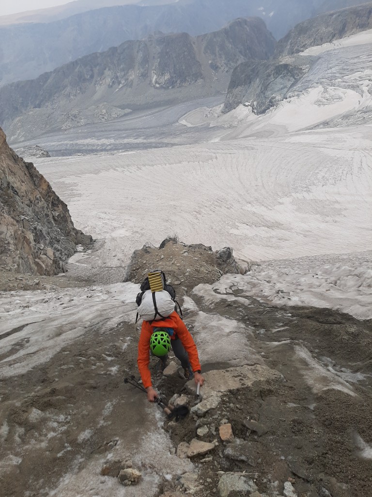

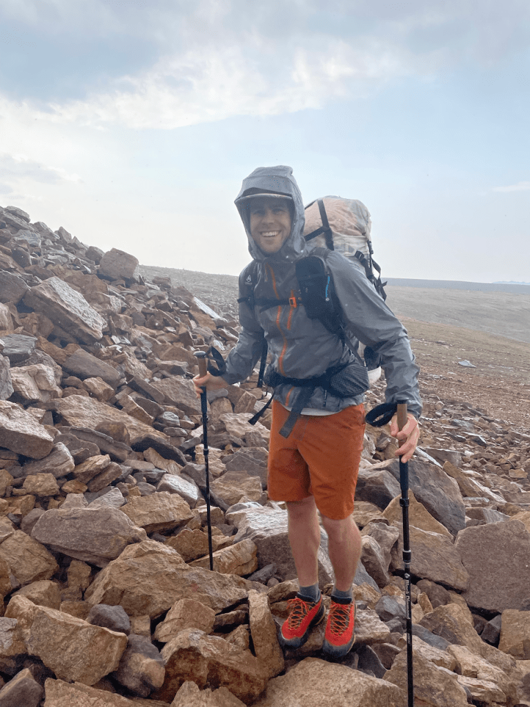
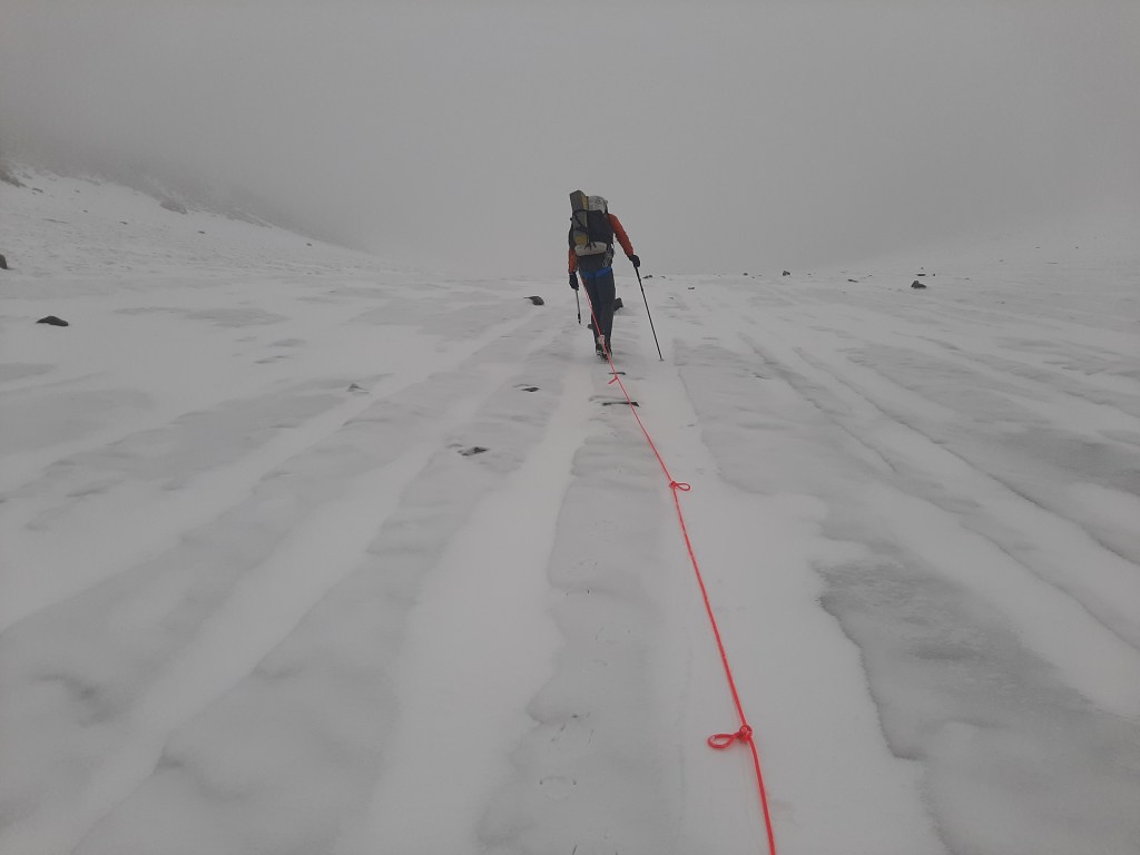
We took our minimalism seriously- no snow protection, no long underwear. We slept in a 1.5lb tarp-tent and climbed in approach shoes. Devon brought leather belay gloves, I had fleece liners. It was a commitment that didn’t accommodate heavy weather. Just 500ft above us, thick grey clouds sat heavily on the flanks of Gannett Peak and unleashed the “wintery mix” promised in the forecast. Climbing anything on Day 4 was out of the question. We focused on staying warm and started to plot modifications to our route and our goals. Day 5 was just as wet, but colder. We stretched our legs and scoped the route during the only brief period without rain. Heavy precipitation tends to increase objective hazards like rockfall and snow movement- we both felt edgy. “Maybe the storm will pass more quickly than forecast.”
Day 6 left nothing to question- the line of fresh snow had moved below our bivy, the flip-flops I was using for camp shoes were miserable in the 2 inches of snow outside our tent. An updated forecast from our Garmin device confirmed there was nothing worth waiting for- the wet weather would hold for 2 more days. We had hoped to climb 6 or 8 peaks in the Dinwoody Cirque, but left with zero. Thick clouds enveloped us while crossing the Dinwoody Glacier, and we only found Bonney Pass using GPS. In Titcomb Basin the snow turned to rain. Combined with getting skunked on climbing our spirits dropped with our altitude. We set camp just above the junction where we would meet a horsepacker on Day 8 to pick up more food, and dried out some gear in a brief period of sunshine late in the day.


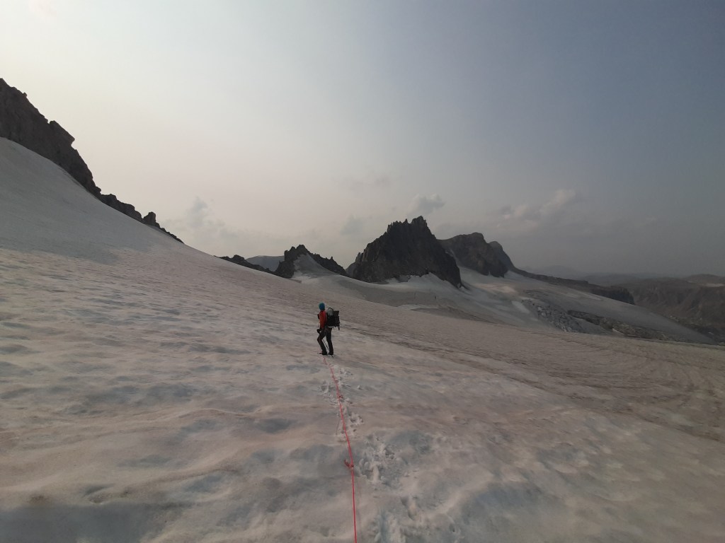
Fremont (13,744ft), Jackson (13,523ft), and Knifepoint (13,001ft) form the Indian Pass basin, and we thought we might tick all 3 in a day. The previous day’s precipitation left a white cap on Fremont, but the air was dry and the itch to accomplish something was severe. The snow started around 13,000ft and gradually increased to legitimate postholing. We summitted, grabbed another NOAA forecast from scrappy cell phone service up there, and headed down. Thunderstorms were expected later in the day, and we hadn’t seen the summit of Jackson come out of the clouds yet. The lowest of the three, Knifepoint felt more interesting and closer, so we sped up the Harrower Glacier and picked our way up loose scree. Wrapping around the east side of Knife Point we didn’t have a good view of the weather moving in. We moved through the snow covered rocks, and once at the summit, the imminent storm racing in from the west was in full view. We raced downhill in a cacophony of thunder and lightning. It’s hard to tell if you backed off an objective too early, but when you wait until it’s too late- there is no doubt. The lightning felt as copious as the raindrops that pummeled us. Back over the col, crampons on down the glacier, then off, stumbling down the moraine just fighting to drop altitude. We were soaked to the bone and ran for an hour to stay warm. The precipitation abated and we walked the last mile to camp. The iron sky hid sunset and any opportunity to dry out. It would be a cold night.
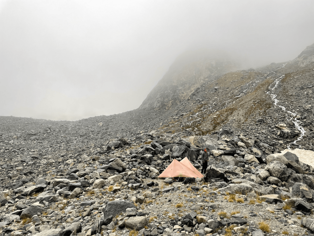
I woke up at 4am with my butt in a pool of water. It had rained all night, but at the moment it was quiet- snow doesn’t pound the tent like liquid. A stream was running under the tent, and my butt was giving the otherwise bombproof fabric more than it could handle. We squeegee’d it out with my extra boxer shorts because a camp towel didn’t make our strict packing limit. With my clothes still wet from the previous day and now my sleeping bag, I was running out of options. Devon wasn’t much better off. I alternated between pushups and squeegeeing to keep out of the puddle.
Around 9am we crawled out of the tent to 3″ of snow on the ground. The same iron skies ignored us and it was still blowing hard out of the west. The temps however, were creeping just slightly warmer, and we decided being out of the tent was better than inside. At 10am the skies started to clear, and by 11am we were sitting in our boxers with everything else laid out in the full sun. Our horsepacker wasn’t due until 2pm so we had nothing to do but wait and giggle at our good fortune.
“Buster” arrived in sunny skies at 130pm. He was probably 22, with a pearl handled .45 on his belt and a mullet. Wyoming as fuck. Our meticulously measured 20lb bag of food was easy work for him and his mule “Donk.” We tipped generously, repacked, and started hiking immediately. With dry gear, a revised plan, and 6 days of rations, we were back in business.


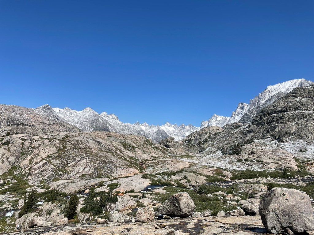
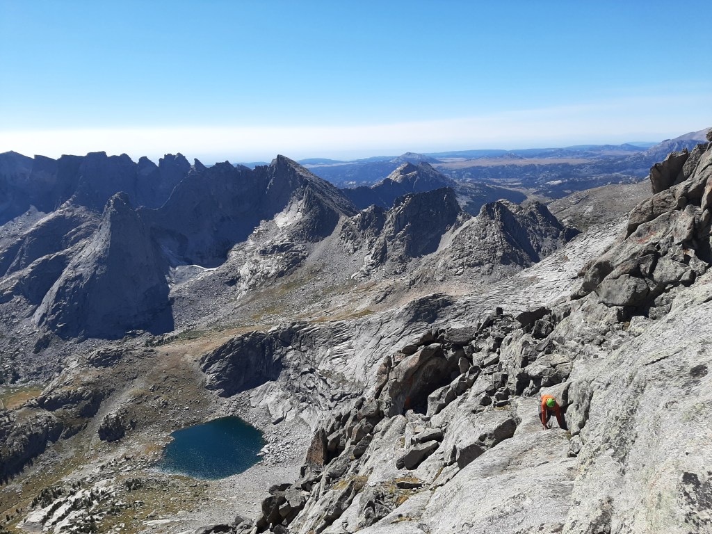
I remember camping at Spider Lakes on my 2002 trip into the Winds, and it was fun to see it was just as beautiful as I remembered it. The morning of day 9 we picked our way up Angel pass, dropped our packs and climbed Angel peak, then continued south on the broad plateau of the divide. We summited Round-Top Mountain and Dennis Peak, then dropped off the plateau to miss a passing afternoon thunderstorm. While we had hoped to stay truly “on the divide,” we found detours were often some of the best parts of the trip. The giant valley below Mt. Victor doesn’t have a trail up it, nor any people in it, but offered fast travel and a good line up Europe peak. After an improbable 3rd class downclimb off the south ridge, we made camp by an unnamed lake in Europe Canyon. It was on the biggest single day of the trip: 16miles, 6200ft of gain, and (4) summits.
Day 10 was gorgeous, but we were sore from the previous effort. We made good time to find amazing camping at Bewmark Lake (note the campside bouldering), then ticked Kagevah and Odyssey peaks in the afternoon carrying only food and water.
“There’s no way I could have done all 43 peaks.”
“I know, me neither.”
“Szu-Ting and Dave are badass.”
Looking through the Wind River climbing guide and most of the photos are credited to Dave Anderson, not to mention a handful of first ascents. While most of the peaks on our intended route were walkups- reading the terrain, knowing the range, and managing the weather are skills that only a dozen years of repeated experience can teach you. We were out of our league but the only way to find out was to try.


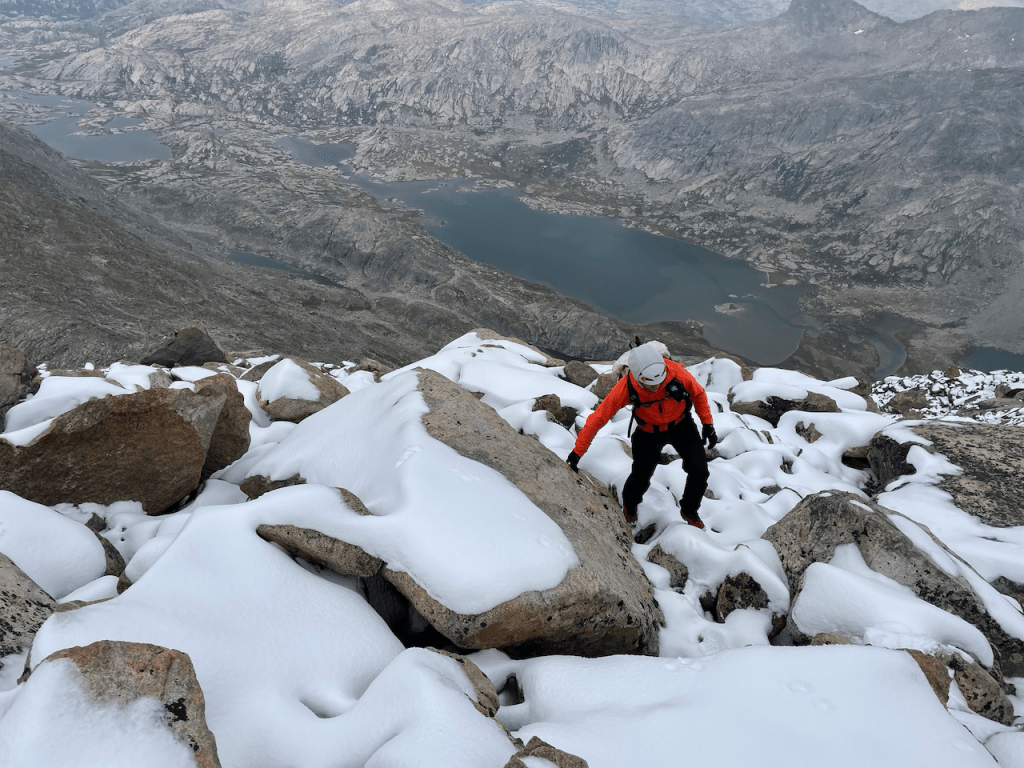
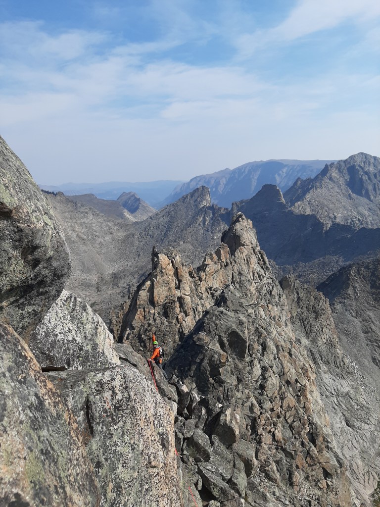
Despite good weather and progress, our stoke was low. We wondered if the goal was getting in the way of the opportunities in front of us. Having missed the much of the technical climbing in the Dinwoody Cirque, ticking all 43 peaks was out of the question. Abandoning that goal freed us up to consider what really felt authentic to us as we were in the field. The Northeast Ridge of Mt. Bonneville commands a striking position at the north end of the East Fork valley, and Devon had put it on a “list of possibilities” we kept at the end of our trip planner. We approached over an unlikely col to the north, and the line stood proudly in front of us. We had already walked past a dozen amazing lines but this one grabbed us both. We made camp early and rested as best we could- despite a few days of sunny weather, the chilly west breeze was unrelenting. The difficulties were mild, but the guidebook description was sparse, and the descent description was unknown. After 11 days moving and plenty of getting humbled confidence for technical climbing remained low.
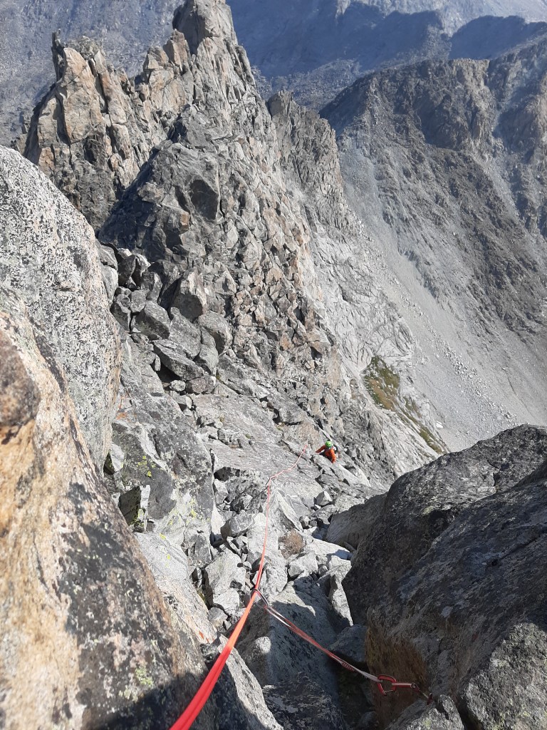
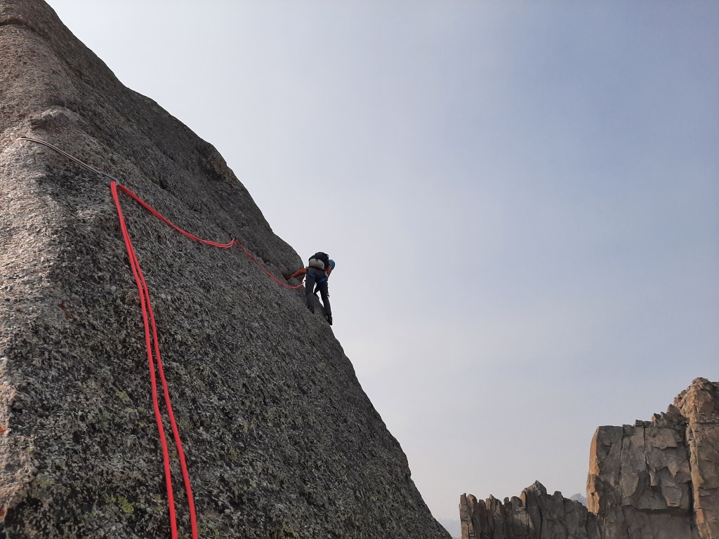
We woke to calm clear skies- we packed camp and stashed the sleeping and cook gear to pick up and move camp after the climb. We approached quickly and moved onto the unroped 4th class terrain easily. Devon’s partnership shifted gears from awesome to expert as we traded route-finding. 45 minutes up the route put us in a bowl that marked the start of roped climbing. Devon led and we simul-climbed once the rope was out. Past some loose business in the beginning, the climbing was fun, and we were a bit relieved to pass rappel stations from previous parties. The true summit was a singular granite block with a short slabby crux- neither of us felt like giving it the go in approach shoes with no pro and huge exposure. The day had already been too perfect to screw up doing something dumb.

We replaced a few rappel cords on the way down and hiked back to camp with mountainous grins. The mojo was back. We picked up our sleeping gear and moved into primo camping at Pyramid Lake. We climbed the south ridge of Tower Peak the next morning and scrambled to the true summit just before noon.
“I’ve got an idea” Devon said with a grin on his face.
“Hit me.”
“It’s too early to head back to camp. Let’s scramble the west ridge of Hooker, then the north ridge of Pyramid.”
“It would be in the spirit of the trip. Let’s blast.”
So we did, and it was a perfect day out. We found some of the most enjoyable scrambling of the trip on the west ridge of Mt. Hooker. The terrain was solid and steep, with great views of the gigantic north face of Mt. Hooker, but still comfortable enough to forgo the rope. We’d had 6 days of splitter weather since the cold and soggy conversation about bailing, and it felt like we were making use of it.

The quadrupedal action of technical climbing left us worked and we were excited to meet our friend Brendan** the next afternoon with 5 more days of food. The following morning was too gorgeous to waste. We moved camp down to the pre-arranged meetup spot, then snuck back up to the divide to tag Bair and Washakie Peaks. Our legs were tired and it felt good to call it only a half day.
We had already found our stoke again, but seeing Brendan and his friend Syd show up with bags of potato chips and homemade brownies put it over the top. They joined our camp and we tore into the unexpected snacks. Our nutrition plan had been “enough” but 2 weeks of technical travel and cold temperatures left us regularly “unsatisfied.” I’m truly grateful that Devon and I never got irritated with one another, but having friendly faces to celebrate our trip and joke around with was a welcome addition to the journey.


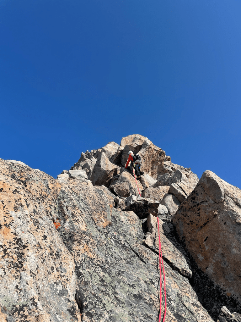
We packed slowly in the morning, and headed south to another highlight: the Cirque of the Towers. On our way over Texas pass, we stopped and got the rope out early. The Kelsey guide indicated a “very fun” 5.5 romp up the west ridge of Camels Hump. Once on top, Devon raised the question I had been trying to avoid from myself- “do you want to go tag Lizard Head Peak?”
Adjacent to Camels Hump, it was achingly close. I replied with a wry smile- “It’s in the spirit of the trip.” And so we went.
We left the rope and rack and scrambled surprisingly complex and technical terrain to tag one more elegant, but unplanned summit. We found camping in the Cirque less crowded than we expected, and ourselves a little more fatigued than we intended. Our fitness would have to hold us a little longer.
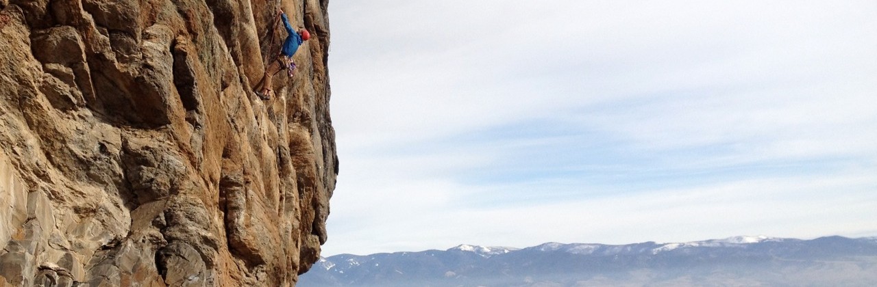
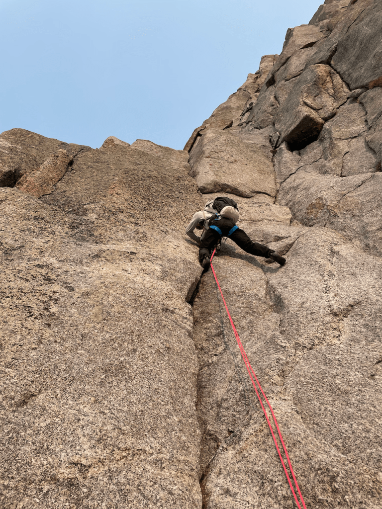
Day 16 dawned smokey, but I was excited to share the rope for a full day of technical rock climbing. We started relatively early, but still the third party up the ultra-classic “K-Cracks” on Pingora. Just as I finished leading the crux pitch, Leo Houlding and his partner Wilson soloed up to the ledge next to Devon on a speed traverse of the Cirque. They hiked the K-Cracks like it was flat ground, I snapped a few photos, and we spent the rest of the day watching them sprint across the distant skyline. It was one of the most impressive things I’ve ever seen in person. We continued, rappelling off the back of Pingora to climb over Tiger Tower, then on to the 50 Classic “East Ridge” of Wolf’s Head. We climbed at our own pace, enjoying figuring out the routes and managing the terrain. It was one of our best days of the trip, and one of only 3 days we saw other people high in the mountains.
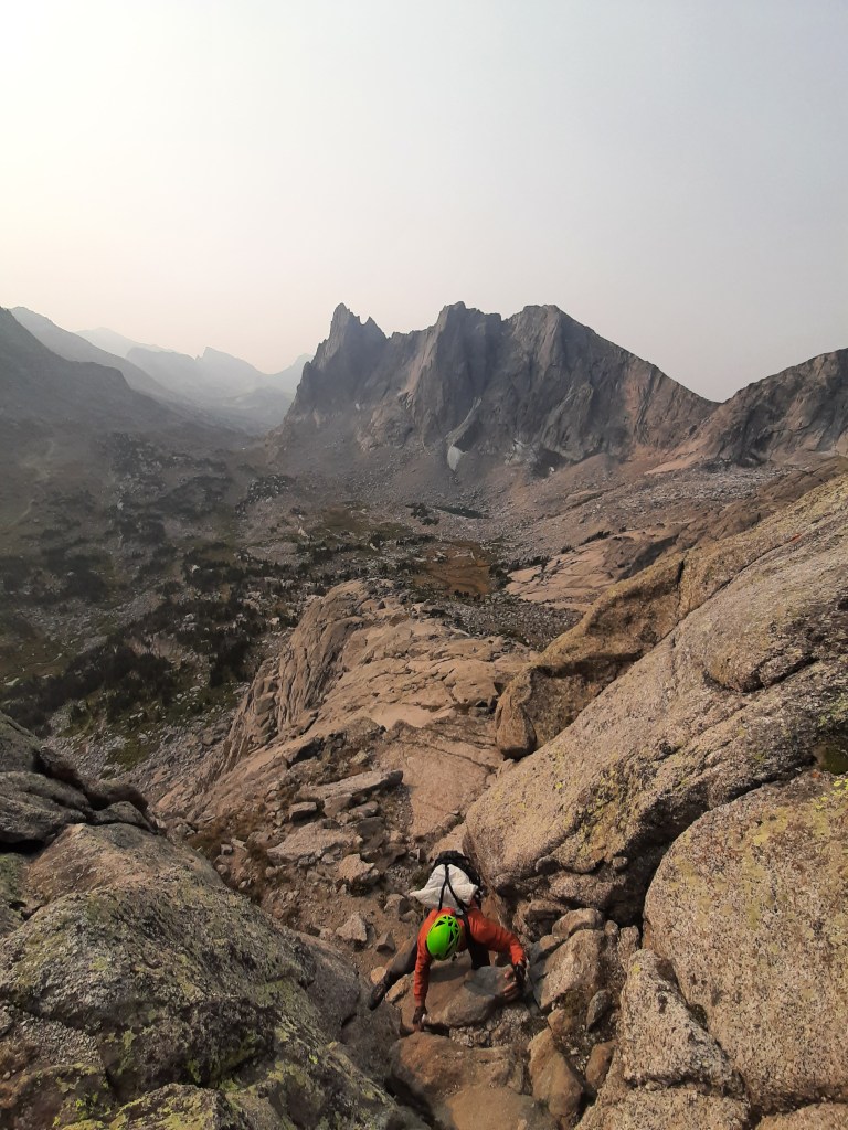

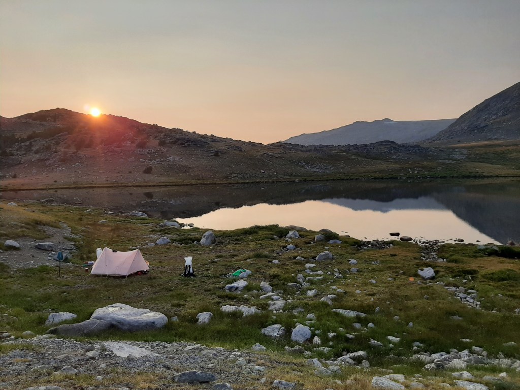
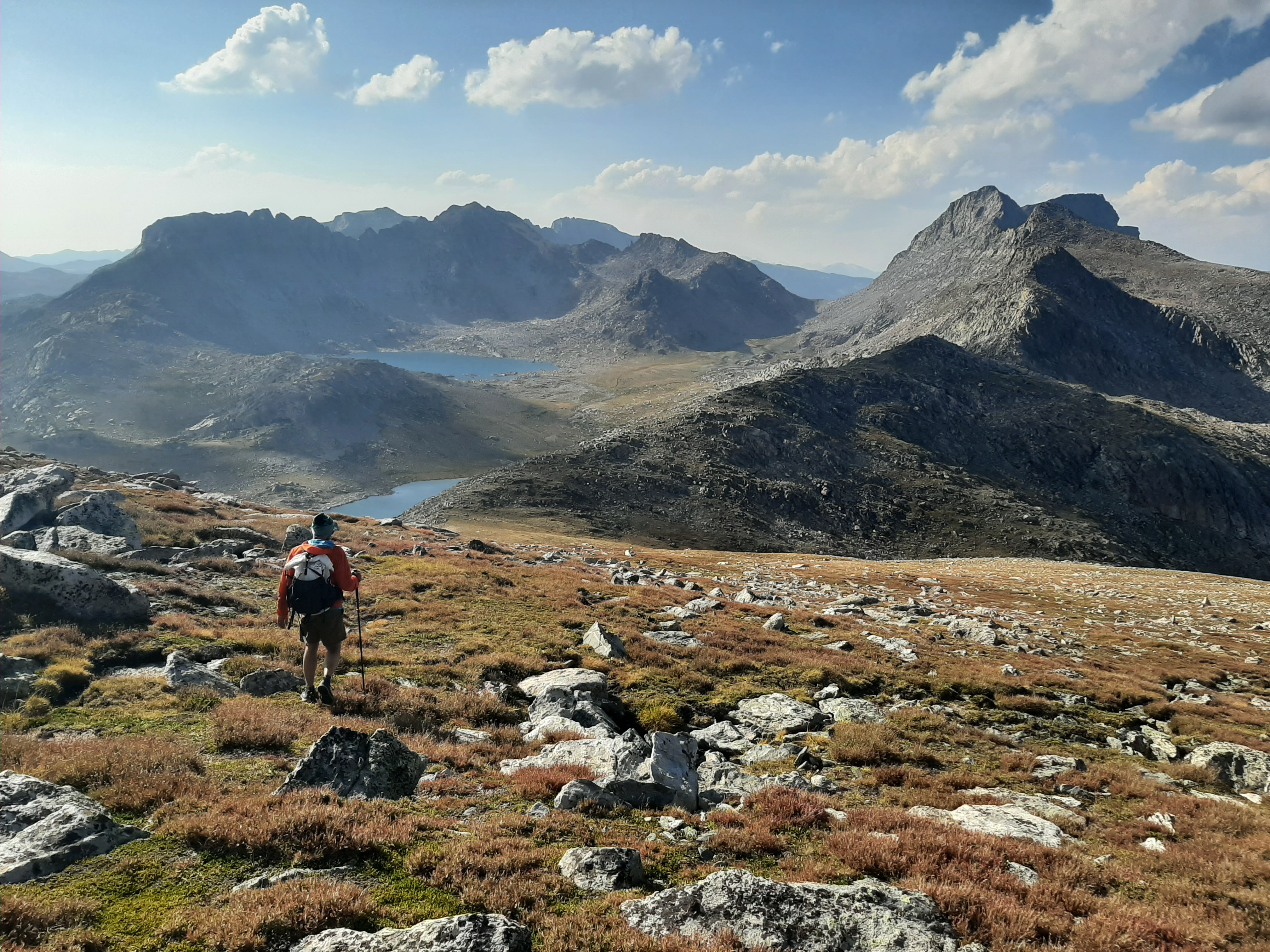
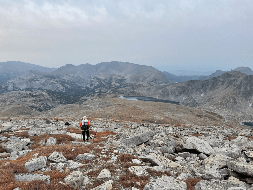
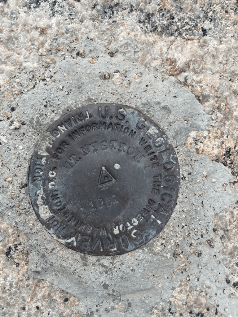
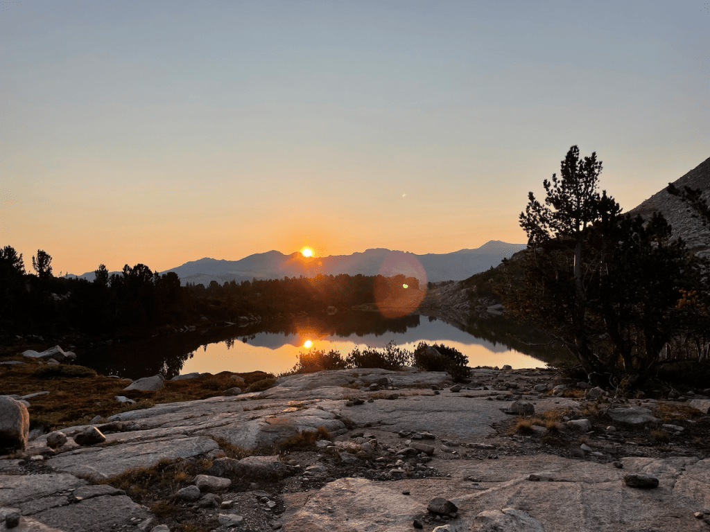
5 more non-technical peaks to go. When we had revised our plan away from focusing on Continental Divide summits, we stayed committed to traversing the entire range- walking down Sweetwater Gap was the only right way to close it out. We left the Cirque of the Towers in heavy wildfire smoke and climbed (3) more peaks. September 1st called for afternoon thunderstorms, and we hoped to tick off the last two peaks, Wind River Peak and Mount Nystrom, before any weather rolled in. Devon had a knack for setting a “guides pace” – we started early and moved unstoppably. The already cold west breeze grew frigid and we hiked in puffy coats and gloves. We topped out Mt. Nystrom at 1pm with clear skies to the north- we could still just barely see the snow on a distant Fremont Peak. Storm clouds started to build and we smiled all the way down an improbable ridge to camp at the headwaters of the Popo Agie river. We woke early, sitting outside in our sleeping bags and watching the last sunrise of our trip. We spoke little- any words felt insufficient to describe the enormity of our experience. Later we packed up and walked 12 miles down to where Sylvia had parked my Prius 19 days earlier- it fired right up.


“What the Winds Tell Us”
19 days
35 summits
186 miles
~65,000ft vertical
We are incredibly thankful to the village of people that helped with beta, training advice, and moral support in making this trip happen: Sylvia Carl, Bryan Miller, Brendan Leonard, Syd Jones, Nate Bender, Dave Anderson, and John Frieh. We used Bald Mountain Outfitters for the horse re-supply- they were easy to work with and professional. This trip was partially supported by a “Live Your Dream” grant from the American Alpine Club. Special thanks to our wives Abigail Adams and Katelyn Reid Powell for believing in us, and trusting us, to get it done and get home safely.
*Pitching friends shamelessly. Sylvia can make you healthier, and Bryan will always make you look good.
**If you like reading about what outdoor adventures can teach us about indoor life, you’ve probably found yourself at semi-rad.com. Brendan is funny as hell and a deeply decent human. If you’ve already enjoyed some of his work, please consider supporting his Patreon.
Copyright: Skander Spies, 2021
