This afternoon I’m headed to gates of the arctic national park. I’ll be back July 26th!
Gates
1 Reply
This afternoon I’m headed to gates of the arctic national park. I’ll be back July 26th!
After getting worked on the traverse, we all agreed July 5 was prime for a rest day. It was tough being at 17,000′ with good weather and not going for it, but I had a stiff headache and didn’t feel acclimatized yet so I knew it was well timed. July 6 I woke up feeling better and our team considered going back up Denali pass for the summit but rooster tails of snow peeling off the ridge indicated it would be a rough day to go. I still wasn’t feeling 100%, and was grateful for another rest day.
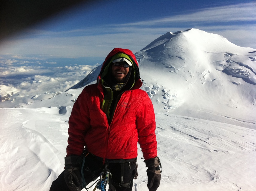
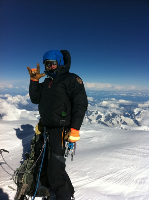
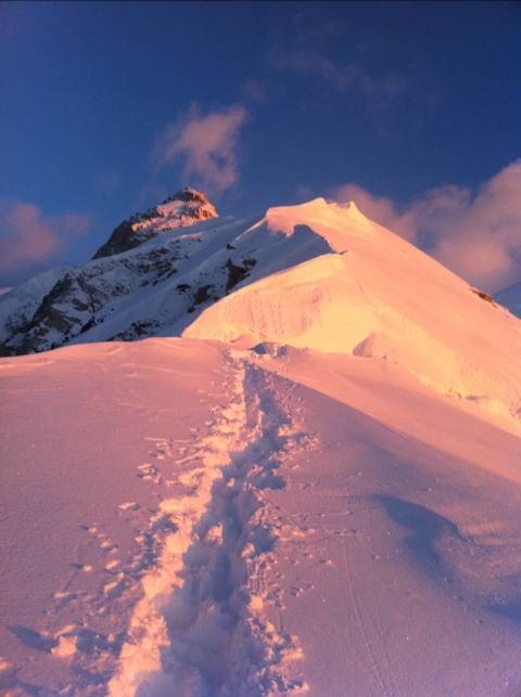
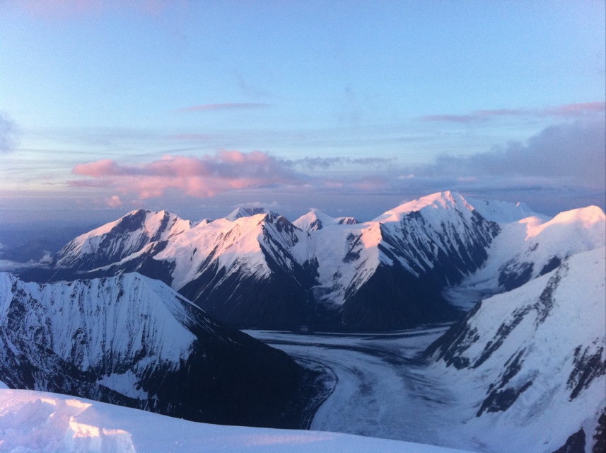
July 7 was go time. The weather was solid and we all felt strong. Given that Chris, Josh, Drew, and I had already been to the south summit (20,320′), our team split up- Tom and Bob going south for their first true summit, and rest of us going north to summit the rarely accomplished north peak (19,470′). The north peak is slightly more technical and remote, and far less popular. Needless to say while Tom and Bob shared the summit with 35 other guides and climbers, we were alone in a different universe 2.5 miles away on the north summit. Once we reached Denali pass we found ourself in an unceasing ~15 mph wind that made the next 7 hours unfortunately cold and miserable. It was closer to the edge of comfort than we would have preferred, but manageable. We summited around 700pm, took a few quick photos and headed for home. An awesome culmination of awesome experiences with 3 incredible men. It was truly an honor to be a part of. I’m pleased to congratulate Tom and Bob on a successful trip to the south summit as well. Back in camp around 11pm, there was no doubt it had been a solid day. Stellar.
(from June 29, 2011)
In wilderness mountaineering breaking trail is one of the more arduous tasks- wallowing in deep snow is tiring, you don’t know where the crevasses are, navigation is difficult, and your energy drains quickly. Teammates share this labor, accepting the risk of hazards, easing the load on their teammates, walking as an example for the others to follow. Living with 5 guys on a mountainside for a few weeks, the examples (and trails broken) of my teammates have been hugely rewarding. For some reason though, being out here has also amplified my appreciation for a number of remarkable women that I’ve been privileged to have in my life- teammates perhaps in the grander adventure of life. My life has been significantly and positively enriched by these teammates, the trail they have broken for me has shown up strongly out here. Maybe because women are simply different from men, or because they do things differently, or because in general women inspire (or require) more humility from men- much as mountians do- the examples deserve note. Funny what stands out in an all male environment. A few of their footprints:
-Cin, flatly rejecting the limits placed before her.
-Margaret, demonstrating outstanding generosity and outward expression of love.
-Kelly, having it all and not being complacent.
-Mackenzie, leaping into adversity and making the best of it.
-Emily, finding creativity in unlikely places.
-Courtney, knowing when and how to let it go.
-Erica, leading by example first and foremost.
Some of these women I have known a long time, some I don’t have the privilege of knowing well enough. All of their paths stand out clearly. To all of you, thank you. Your footprints make finding my way a great deal easier.
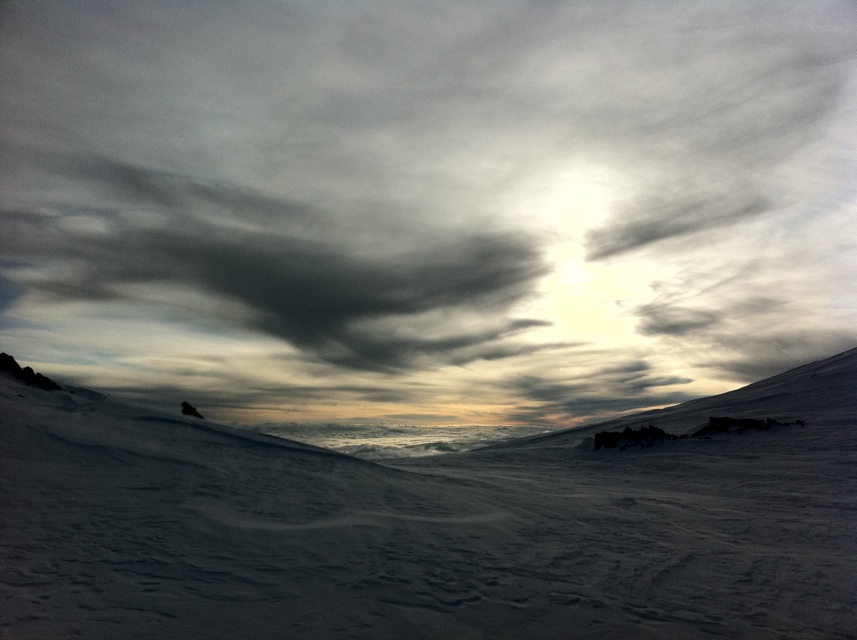
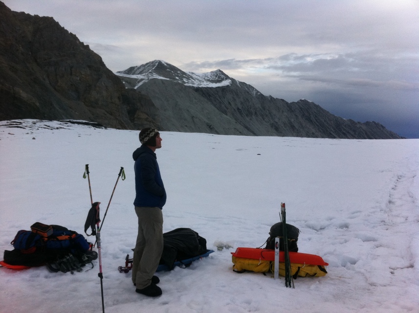
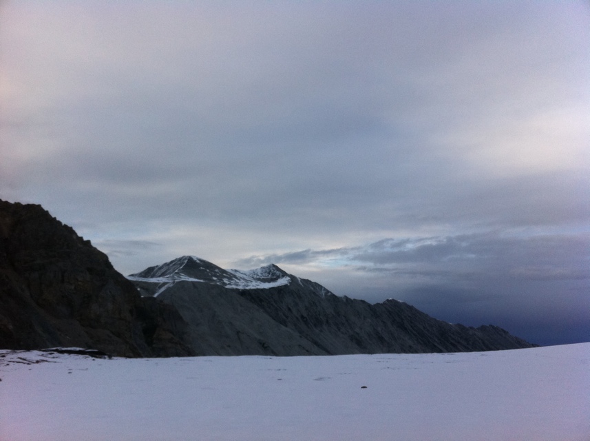
The Harper glacier could be considered an extension of the Muldrow, but with a distinctly different flavor. After the Icefall we skirted on Karstens ridge, the Harper exists solely above 15,000′ and is one of the coldest, most windswept, and barren places in commonly travelled mountaineering. Stories of demolished tents and bitter temps humbled our expectations and set our senses on edge for this portion of the route.
After rescuing the Russian guys, the weather closed in and we declared a rest day. July 3 we woke up ready to roll but found our tracks from June 30 covered by over 3 feet of fresh snow. The trail breaking was absurd and visibility was almost nil. We could feel the trail undef the snowpack, but could see it. As the third guy on the first rope if I stepped incorrectly, I was buried in bottomless powder up to my chin. We took turns breaking trail, the visibility lifted and slowly we worked our way onto the upper Harper. Late in the day I broke trail again through the Icefall. I probed our old track and kept an eye on our wands but still managed to take a cravasse fall over my head. This time the crack was dry and I was able to get myself out quickly, but I was happy to have solid rope mates behind me. Despite a full days effort we didn’t make it back to the cache we had put at 16,800′. We camped cold and tired in the seracs at 16,200′.
July 4 was a day to remember. We packed camp quickly, picked up our cache, and pushed up to Denali pass dragging sleds. The park service needed our team to staff the 17,000′ camp on the West Buttress, so we completed out traverse and headed down Denali pass carrying over 100lbs each between packs and sleds. Before descending the pass we enjoyed meeting the NOLS team coming down from their successful summit push- way to represent guys. It was good times but descending the pass with sleds was maddening, and we got worked. With skis and wands on my sled it did nothing but barrel roll down the pass, attempting to pull me off with each turn. Everyone else’s sleds seemed to slide fine. The profanity emanating from my mouth was not one of my finer moments, and hitting the 17 camp never felt so good. We had completed the traverse and were in spectacular position for the summit.
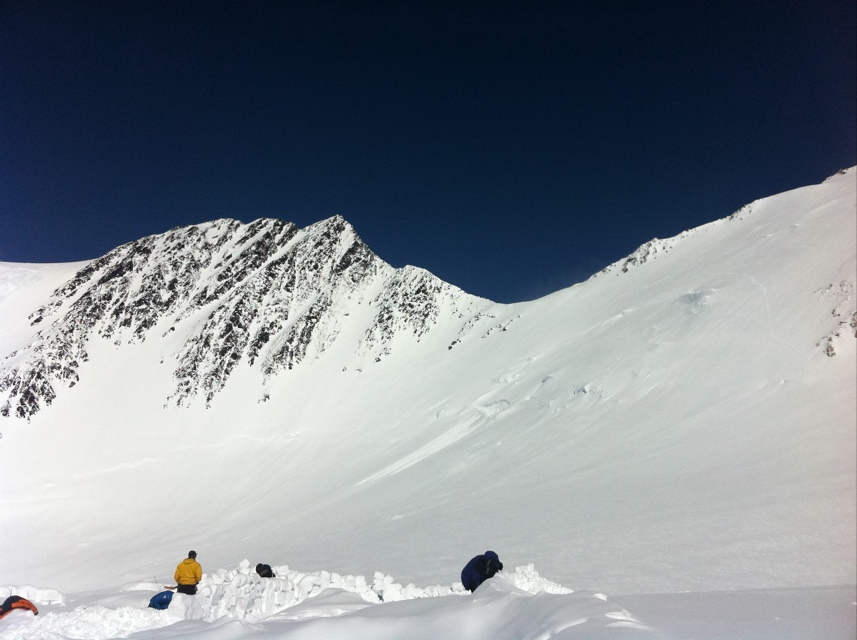
Having got all our gear to Browne Tower we were excited to be in such an awesome position on the route with plenty of food and fuel for a potential summit push from the upper Harper glacier. Our campsite was less than ideal, having carved it out of a 35 degree avy slope, but it worked, and June 30 we moved a cache of gear up to 16,900′. Above Browne tower lies the Harper glacier, a cold, windy place with a reputation for destroying gear, morale, and people, and being the second to last major obstacle of the trip. Moving a cache allowed us to acclimate to the high elevation, build some walls for a future camp, and get a feel for this tough, wild place.
When we got back to camp, the Russian duo we had been concerned about stopped by and asked us to look at one of them. Due to Park Service rules about patient care we knew that assisting this group might have a massive impact on our trip. The team had ascended the route too quickly, and one member showed serious symptoms of both high altitude pulmonary and cereberal edema- potentially life threatening conditions. The morning of July 1 we officially took the patient under our care- his oxygen saturation was in the mid-30s and it was obvious his partner was unable to care for him. We spent the day outlining various options for rescue and waiting for his response to drugs- while a rest day, it wasn’t very restful. It was snowing heavily with low visibility, heavily loading the avalanche terrain on the ridge below us. The Muldrow is a remote route without many good rescue options and significant terrain hazards- a crappy route to rescue someone off of. Late that night rangers in Talkeetna decided that a helicopter evacuation was the best option but that required far better weather. The snow finally stopped and we used the window to scout and prepare landing zone for the helicopter. The morning of July 2 we had a short window of clear wether, got the helicopter in, got the patients out, and had a special delivery of cinnamon rolls from the local bakery.
The weather closed again immediately after the rescue and continued to dump snow. We declared another rest day and started to wonder how hard getting to our cache would be with almost 3 feet of fresh snow covering our tracks onto the Harper.
After the Great Icefall, the Muldrow glacier technically ends in a large bowl below a massive jumble of ice- the Harper Icefall looks like a giant alligator waiting to eat you. Fortunately the mountain provides gorgeous detour around this feature by following Karstens Ridge for approximately 3,000 vertical feet just east o the Icefall. This ridge is arguably the most beautiful and engaging climbing of the route.
June 23 we carried most of our food and fuel to the base of the ridge at 10,800′ and scoped a plan to get on the actual ridge (one of the hardest parts). June 24 we packed up camp in good weather, gained the ridge, and built a new snow camp at 12,100′, passing our cache below us. We knew there was some hazard in leaving an avalanche slope between us and our cache at 10,800′ but we wanted to take advantage of good weather, and felt like the short gap between us would be doable in most conditions. The 12,100′ camp is likely the most beautiful place I have ever camped, and offered views above most of the surrounding peaks.
As might be expected, June 25 saw us hunker down for our first weather day (hard blowing snow and low visibility) loading the avy slope between us and most of our food. We had enough to wait two days, but I wasn’t impressed with my response to the first real threat of food stress. We decided to scope out conditions on June 26, and spent a long 11 hours very carefully mitigating avy hazards to get our cache up to the ridge camp that evening.
Also at 12,100′ we caught up to a large team from NOLS, and a 3 person team from Massachusetts both whom had left about a week before us. It seemed a little funny to have 3 teams on a remote wilderness route all stuffed into a small ridgetop camp, but it was fun to share the experience with new faces.
NOLS had already broken a trail up the ridge for us, so June 27 we moved a cache to 13,600′ on the ridge and returned to camp. The terrain on the ridge was steep and exposed, normally this wouldn’t have been a problem but with a huge pack I felt unsure of myself. That night we met a fourth team at 12,100′- two Russians that had started two days after us and were moving quite fast, and something triggered our suspicions.
June 28 we broke camp and moved up to Browne Tower, a huge granite feature at the top of Karstens Ridge, along with all of the others teams. Campsite space here is limited and building camp was extremely laborious- NOLS got out of camp first and grabbed the best spots for their huge crew. I went to bed worked, but excited to be high on the route at 14,600′. June 29 we took it easy and retrieved our cache from 13,600′ and absorbed being truly above the clouds within direct sight of both Denali summits.
When the path of a glacier flows over a particularly steep piece of a mountain it forms a feature called an icefall. Typically these areas host many cravasses, huge broken chunks of ice, and terrain that makes travel both difficult and scary. The standard Muldrow route includes travel directly through 3 major icefalls, and based on my recent cravasse fall experience, these were somewhat the mental crux of the route for me. Icefalls tend to change from year to year, storm to storm, and temperature when traveling in them.
The Lower Icefall of the Muldrow was the first of the three icefalls, and the one in which we had the heaviest loads to carry. For a variety of reasons, I elected to use tele skis and skins for floatation on this trip partially because they do a better job of keeping people out of cravasses than snowshoes. Unfortunately, they make traveling throughout the dense broken terrain of icefalls much more difficult, especially while pulling a sled. We found a partial trail left by previous parties but it still took quite some work to navigate. Due to the difficult terrain and size of our loads we started double carrying, spending one day carrying a cache higher on the route (through the icefall), then returning to camp the night and moving our tents and other gear the next day- if it sounds like it makes the climb twice as much work, you’re right, it does. It also makes the experience workable rather than unbearable, and I found it allowed me to enjoy the incredible place we were in. This is a typically strategy for most teams and most of the route until reaching the Harper glacier at 16,000′, so we had lots of work to do. The Lower Icefall went smoothly, no falls or other surprises, but we ended up caching our gear earlier, below the hill of cracks, rather than the base of the Great Icefall as is typical. When we moved camp from below the Lower Icefall we decided to move past our cache and through the Great Icefall with lighter packs and hopefully finding better camping at approximately 10,000′.
The Great Icefall of the Muldrow also went smoothly and without surprises, but was a pretty spooky place to be none the less. Home to some of the wildest and gnarliest ice formations I have ever seen, it is a feature to respect and move through (and yes we double carried through it). Again previous tracks help point us in the right direction, and we were stoked to dig into flat, safe camping once we got uphill of the Icefall. Travel and weather conditions through both of these Icefalls varied from perfect to terrible, but being on a night travel schedule helped make them somewhat more predictable. If doing the route, expect anything from brutal cold to uncomfortably warm temps, sticky/gloppy to styrofoam snow, rain and snow precipitation, whiteout to clear visibility- the full gambit, during this portion. We got it all in four days. Night schedule is recommended as it makes snow bridges over cravasses more stable and temperatures easier to predict. Skinning throughout the Icefalls was some of the most difficult and frustrating time I have ever spent on skis- I would actually recommend snowshoes for the route because of their lighter weight and better mobility. As we had passed our cache in a big push to camp above the Great Icefall, we returned the next night to retrieve it, I led our team back up the track pulling amsled and heavy pack into a cold down glacier wind. I don’t think my hip flexors have ever worked so hard and it seemed like this last carry through the most difficult of the 3 Icefalls provided our team with the first opportunity to truly suffer together. Suffice to say I was very grateful for the mental training provided in my sessions at Crossfit Fort Vancouver, and mental strength of my teammates. We earned our hot drinks that night.
(from June 19th, 2011)
When I moved to Portland four years ago I was just learning to be an adult- sorting out challenging circumstances and defining myself in a new city and new position in life. A friend of mine had this title phrase posted on his instant message status and the two words were exactly what I needed to think about. Steadiness, making good decisions on good information, slowing things down, and embracing adversity helped sort out the mayhem. Bebop, a music that I grew up playing, involves creativity, energy, and intelligence- all qualities I wanted to make sure I had in my newfound west coast life. I only found out some time later that my friend was referring to two thuggish characters from the Teenage Mutant Ninja Turtles.
Ever since, the phrase has reminded me of the petty drama I entertained during that period of my life and exactly how to beat it. Hauling a heavy pack and heavier sled up a glacier there’s a lot of funny stuff that can get in your head because you are worked. Planting each step and humming a little jazz reminded me how to finish a strong day, rocksteady and bebop.
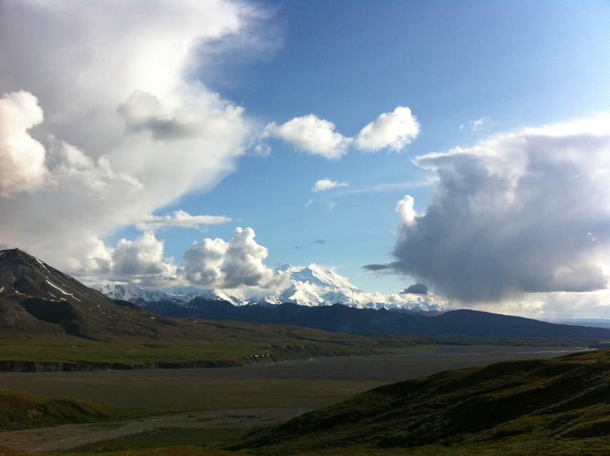
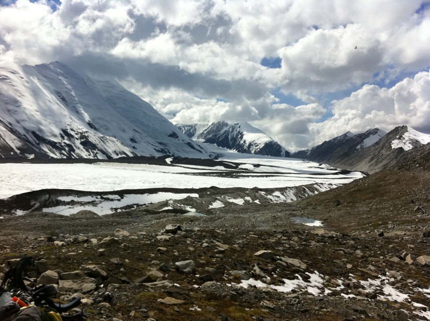
At 34 miles, the Muldrow glacier is the largest glacier on the north side of Denali National Park, and hosts the route that was used by the first successful attempt to climb the mountain. In every sense, the route is a true Alaska adventure, a massive undertaking involving a variety of physical and mental hazards in a truly remote wilderness setting. It was a privilege to be invited to patrol the route as part of a national park service team and an opportunity to complete a lifetime goal. Unlike typical Denali park service mountaineering patrols, we had a minimum of support and climbed the route with a similar style and itinerary as most other parties on the route.
Starting at Wonder Lake (elevation 1,800 feet) we started on the flat , 85 miles from the nearest paved road, 45 horizontal miles, and 18,000 vertical feet from the summit. We started hiking around 10pm on June 16th in trail runners, plastic boots hanging off the outside of our gargantuan backpacks. We had some cold weather gear, snow floatation and 16 days of food inserted by helicopter (most teams use a dogsled to deposit this cache) waiting for us at McGonagall pass, 22 miles of backpacking south of the lake. Still my pack weighed in at 71 pounds and the hike to the pass was definitely physical. We crossed the McKinley bar river at 7am June 17th in hip deep, ice cold water. The crossing took about 3 hours and I’ve never had the screaming barfies so badly in my feet. In review, our team felt like the crossing was just barely within our risk tolerance, we were grateful for every cfm the river dropped the night before we crossed. The remaining hike to the pass was largely straightforward, and tremendously enjoyable The have been a number of parties up the route this year, and a defacto trail has worn into the taiga, allowing us to make the pass in just 2 days. We had outstanding sunny weather, great views of the mountains, and a solid time getting to know each other. The mosquitos were authentically thick, but spirits stayed high and standing on top of McGonagall pass is one of the most beautiful places I have ever been.
We found our cache perfectly placed on the glacial moraine, and we spent several hours sorting the 500+lbs of food and gear into sled loads. We used kiddy sleds to make the backpack loads more manageable, and June 18th we single carried all our gear to a camp below the lower icefall.

The last 30 days have been very full to say the least. Certainly the climbing experience has been unique, incredible, and challenging, but the opportunities for personal growth and lessons learned from an incredible group of men have rounded out the time with plenty of writing to share. The following entries describe our climb in sections of the route- and between sections I’ll be posted some account of my thoughts and reflections from another incredible trip in the Alaska range.
I’ve been writing solely on my iPhone, so please excuse typos and punctuation errors, entries are time consuming enough just to get down in a digital format. I’ve been able to create posts on my iPhone while climbing and include some photos, but will try to post more photos from my teammates once I get to a computer. I have very little time in between trips, so I apologize for the barrage of posts in a short window! As always, thanks for following.